
Where in the world is Totnes?
Article by Lucy Oldroyd and Kate Wilson, Totnes Museum
Last weekend as part of the Respect Festival in Leechwell Gardens for Totnes Fringe, the museum put on a display about the other Totneses. We called it ‘Where in the World is Totnes?‘
There are 4 localities. Totness in Suriname is the only one which has survived to be a true town. The two in South Australia have been subsumed by adjacent named locations and Totnes in Saskatchewan disappeared back into the prairie.
The display with more images and information is now up at the museum for the month of July
But where in the world is Totnes? Today we know Totnes as a flourishing riverside market town in Devon with a population of around 9000.
The recorded history of Totnes, Totness, Totta’s Ness, Totta’s headland begins in 907 CE when King Edward the Elder fortified the headland to create a burh or fort as protection from Viking raids.
The River Dart has provided Totnes with wealth and a link to the world. Totnesians have travelled far and wide and some have created settlements which they named ‘Totnes’ far from their Devon birthplace – in Saskatchewan, Canada, in Surinam, South America, and Mount Barker and Mount Pleasant in South Australia. The reasons for naming these new places after their homeland will vary – maybe the settlers wanted to maintain a connection with the comfort of home. Perhaps they were intending to stamp their ownership on new and unfamiliar places. Or maybe they were hoping the new settlement would aspire to the success of the original.
Whatever the reason, these other settlements called Totnes are widely scattered across the globe and have very different foundations and stories. Their stories can talk to us about about our history and our place in the world.
Totness, Suriname, South America:
A small town of around 3000 inhabitants in the Coronie District of Suriname on the north eastern Atlantic coast of South America.
From the 4th millenium BCE this land has been home to the Lokono, Kalina and Wayana people. Guiana is an indigenous term for a ‘land of many waters’ which describes this coastal strip of South America, becoming applied to several countries in the region. In the 16th century, English, French and Spanish travellers began to visit. In 1594 Walter Raleigh came to search, unsuccessfully, for gold. In 1652 Sir Francis Willoughby of Parham, established a colony on an island in the mouth of the Surinam River, which became known as ‘Willoughby Land’. In subsequent years Spain, England, France and Holland competed with one another to colonise and exploit the resources of the region.
Today, British Guiana is now Guyana having gained independence in 1966. Dutch Guiana included the regions Demerera, Essequibo, Nickerie and Surinam and today is Suriname having gained independence in 1979. French Guiana remains part of France.
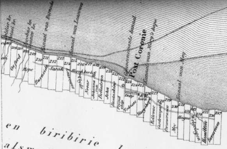
Totness was settled from 1808 but why it was named Totness is not clear. It may have been named by John Bent, who was born in 1776 in Kenton. He is recorded as being the MP for Totnes 1820-1826, served as Commissioner in Surinam from 1813 to 1814 and is recorded as owning slaves there.
Surinam was a Dutch colony, but between 1799 and 1816 it was often under British control. New coastal plantations were laid out in an area was known to English speakers as the ‘Colony’ and to Dutch speakers as ‘Coronie’.
In 1821 two plots of land, 223 and 224, became the property of John Bent who also owned the cotton plantations Sarah, Descanzo, Pietersburg, and Domburg. By 1832 Plots 223 and 224 had become a cotton plantation with the name ‘Totness’.
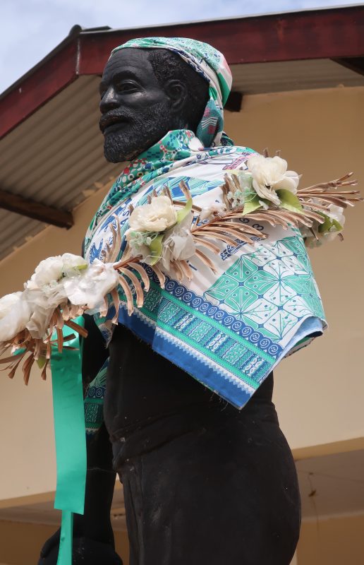
Sugar, coffee and cotton plantations were established using the forced labour of enslaved Africans. In 1835 Tata Colin (circa 1806-1836), a slave, led a slave rebellion on the plantation Leasowes near Totness. He was captured, tortured and sentenced to death but died before the execution could take place. A statue stands in his memory in Totness central square and a school is named after him.
Totness was acquired by the Governor as a site where previously enslaved people could own land following the abolition of slavery in 1863. By 1909 there were 786 small scale farmers cultivating cocoa, bananas and coconuts on what had been Totness plantation. For many years the area was linked to the capital Paramaribo only by sea, but this changed when a road was constructed in 1940. Totness has a multicultural population reflecting its complex colonial past. A predominantly agricultural economy has more recently seen new developments in ecotourism aiming to preserve and promote historical plantation sites and the tranquil coastal and mangrove landscapes.
Totnes, Saskatchewan, Canada
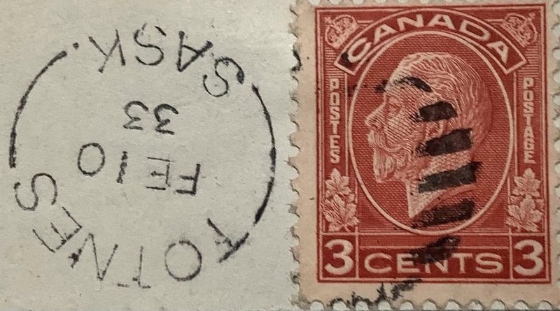
It is not known who named Totnes in Saskatchewan, probably in the early 1900s, but by 1923 Totnes was a tiny hamlet on the Canadian Pacific Railway line, southwest of Saskatoon and 22 miles from the town of Eston.
The Indigenous First Nations peoples of Saskatchewan, the Nêhiyawak (Plains Cree), Nahkawininiwak (Saulteaux), Nakota (Assiniboine), Dakota and Lakota (Sioux), and Denesuline (Dene/Chipewyan) have inhabited these lands for around 11,000 years. From 1670 the Hudson’s Bay trading company claimed all of Western Canada. To the First Nations people of Saskatchewan this European contact brought disease, economic and social disruption.
Canada commenced Treaty agreements with First Nations and Métis (people of mixed First Nation and French descent) in 1867, but disputes led to rebellion. The government’s response was the dispossession and repression of First Nations and Métis people including forcible confinement to reserves and cultural effacement including the removal of children to Residential Schools for assimilation. Immigration to the Prairie Provinces like Saskatchewan boomed between 1867 and 1914, driven by Government and Railroad Company advertising campaigns. Settlers came from Britain, Europe and the U.S.A. but also from China and Iceland, seeking greater economic opportunity, escape from oppression or persecution and a better quality of life.
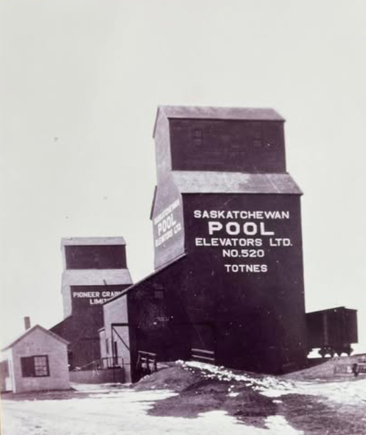
Totnes never grew larger than a small village. There was a post office, a one-roomed school, the Acadia School, and two grain elevators. Eventually, new roads bypassed Totnes and people shifted to larger towns nearby. The name ‘Totnes’ now describes a rural locality, but all traces of the town are erased.
Totness, South Australia.
The name of Totness was given to two separate locations, at Mount Barker and at Mount Pleasant on the country of the Permangk people located in the Mount Lofty Ranges to the east of Adelaide, South Australia. The Peramangk peoples were known as the ‘Fire Makers‘ and as ‘Red Ochre‘ Peoples as they used and traded ochre, flint and mineral pyrites. Though the population cannot be known for certain, at the time of European colonisation it is estimated that approximately 600 Peramangk dwelt around Wommamukurta, the ‘mountain on the plain’, today called Mount Barker and at least 1,200 across their whole national area.
Wommamukurta was an important meeting place for inter-tribal gatherings and a source of ochre pigment. The Peramangk, Kaurna and Ramidindjeri peoples of the Adelaide region carefully managed their lands to ensure plentiful food production. Their role in developing the landscape was neither understood nor appreciated by Europeans. South Australia was created by an Act of the British Parliament in 1834. The British Crown took possession of the region and no Aboriginal person would know of this until Governor Hindmarsh arrived in 1836.
Early contact between the Aboriginal peoples of the region and European settlers was initially peaceful but conflict developed over access to land and resources. Today there are many descendants of Peramangk, Kaurna and Ramidindjeri people living in South Australia, including the Adelaide Hills region, reclaiming and revitalising their culture.
South Australian Migration
Between 1840-1900 – 434,806 people left Britain through a Devon port, the majority of these went to Australia (only 1.1% went America). Devonians learnt about South Australia from promotional lectures, newspaper advertisements and via letters from family members or friends who had made the journey which were also often published in local newspapers. The example of the migrant ship Duchess of Northumberland is typical. She carried 227 passengers and arrived in Adelaide in 1839.
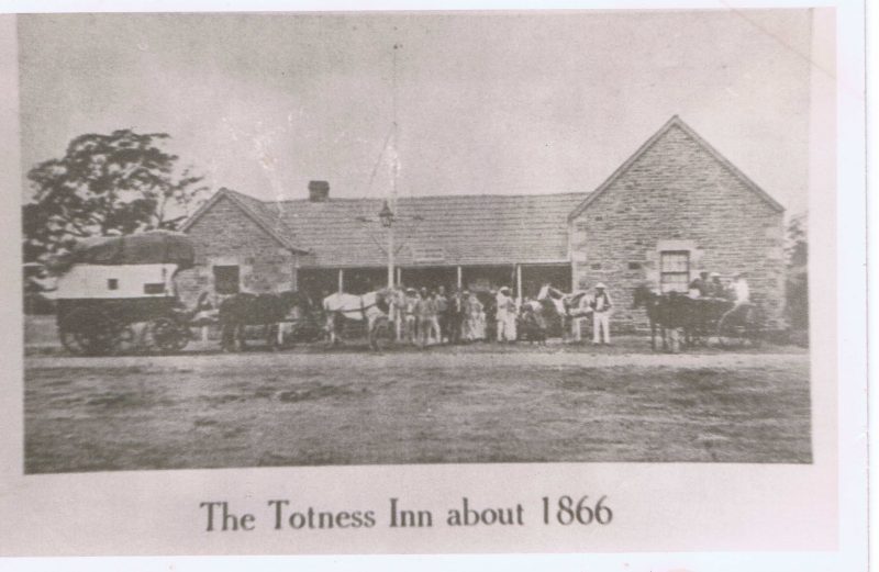
Amongst those with free passage on board were William Colton (Harberton) and Charles Thomas Hewitt (Totnes) , described as farmer friends who migrated together with their families, servants, livestock and equipment. On Christmas Day in 1839, William Colton and Charles Hewett were conducted on a tour of the South Australian Company’s southern land sections to choose their farms. They were accompanied by William Beavis Randell, born Berry Pomeroy, migrated 1837, stock manager for the SA Company.
Also on board the Duchess of Northumberland were:-
Henry Elliot, born Totnes, an employee of William Colton, who would write home to Devon and encourage another family member Susannah Hannaford nee Elliott to migrate with all her family. Her son, William Hannaford named the Totness area at Mount Barker. This location today is a semi-industrial suburb of Mt. Barker, a city with a poplulation of around 46,000, located 21 miles south-east of Adelaide. This location also contains the Totness Recreation Park, protecting around 100 acres of remnant and now uncommon stringybark, blue gum and manna gum bushland.
Mary Ann Tippett born Harbertonford, married Henry Giles, the developer who named Totness, now part of Mt. Pleasant township. The town with a population of around 1000 people, is located 34 miles north-east of Adelaide, on the banks of the River Torrens and services a farming district of arable crops, viticulture, dairy and sheep.
An extract from a letter sent by Henry Elliott, to his brother was published in the Western Times of 18 December 1841. He writes from Oxenberry Farm, Onkaparinga, the farm established by William Colton at MacLaren Vale. ‘ In England, where there is so much rent and taxes to pay, if a man is born poor he is kept so. If you had come out when I did, you would now have a few acres cultivated for your own use and a sufficiency for your family, which you can never have in England. There are thousands of acres of beautiful land here uncultivated, whilst you have not half enough to live upon….Who would stay home working hard and always poor, when, in Australia, a man who is steady and industrious can live happy without the dread that as soon as a fellow’s labour is done he will be clapped into the union?‘
William Colton, published Western Times, 1840
‘ I now address you, and will give you an account of that much talked of colony. It fully answers my expectations – I took possession of my farm about three weeks after my arrival, it is situated in a very pleasant vale, (where the water is good and abundant,) surrounded with hundreds of acres of land of excellent quality – as good as any in Harberton;…. We want Devonshire farmers, I think they will do well in this country. Please to tell Mr. C. Michelmore that I do not regret leaving, as I can do much better here than on any estate he could get me in England.’
Many thanks to the following for help with information and images:
Stanley Oldfield, Harberton and Harbertonford History Society
Mount Pleasant Community Association
David Alston, Slaves and Highlanders
Historic Saskatchewan and Prairie Sentinels of the Past on Facebook
Main Header image: Totness Post mark, Saskatchewan, Canada